Left-click and drag to rotate.
Scrollwheel to zoom.
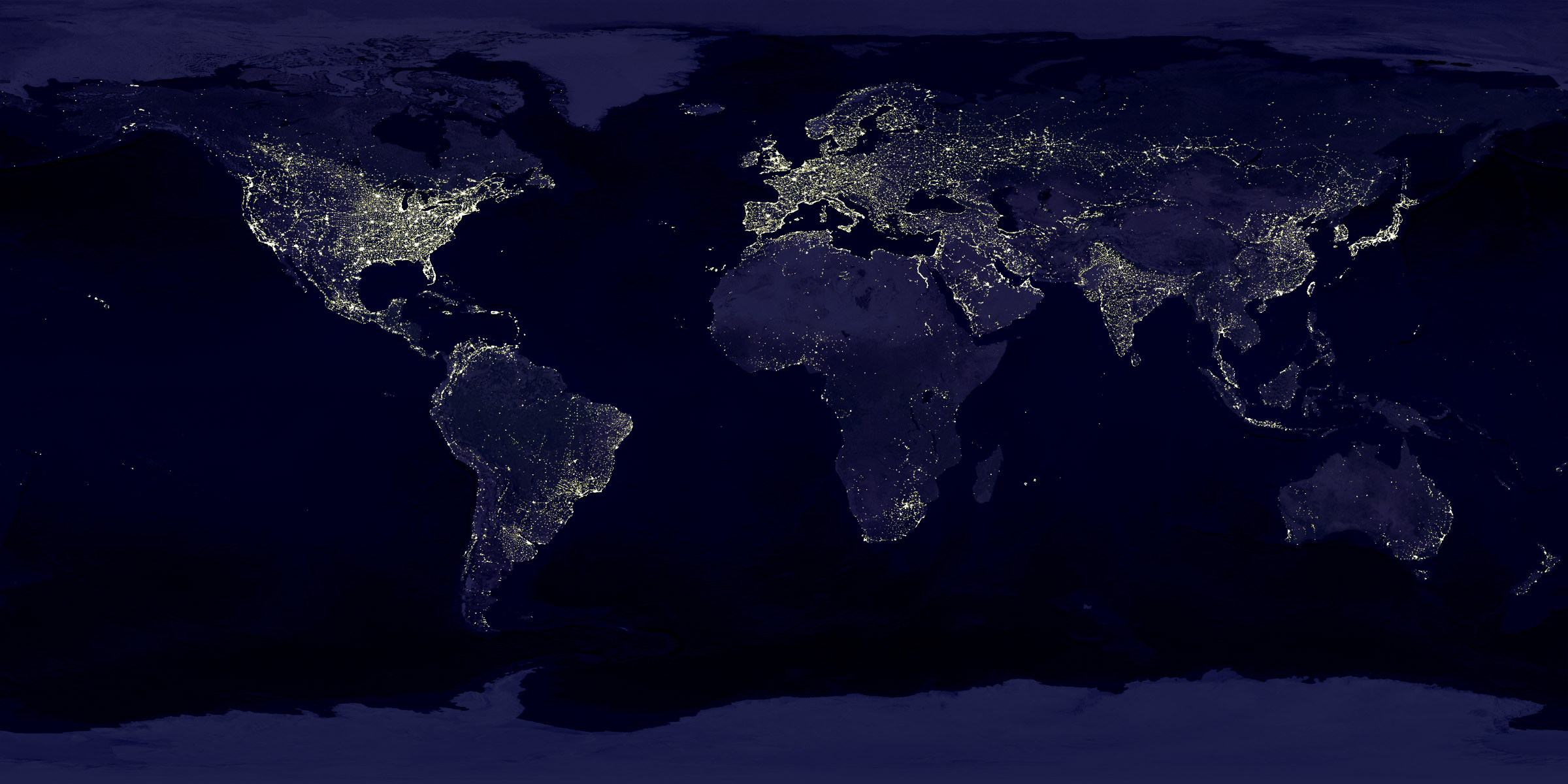
The main image map. This is what you'll see over the globe.
This image will show on the dark side of the globe if the atmosphere effect is enabled. Usually looks something like this.
A heightmap image will add a mountain (or height) effect to the globe. Heightmap images usually looks like this. The higher the elevation, the more white that area should be on the map.
An image used for the background.
The seed number is a number that is used in the algorithm to generate the world. The number can be anything. The same seed will always give the same resulting world.
Essentially the amount of detail in the image. Higher values will give a smoother looking image while lower ones will give blockier images. A high resolution value will also take a lot longer to generate. If you want to play around with generation, start with a lower resolution number until you get a world you like. Then bump up the resolution value to get a better final image.
High noise values give smaller "land" masses while lower noise values give larger ones.
This value controls the amount of detail in the final image by increasing the number of times the noise function is run. A low number generally produces much smother noise areas (i.e. land masses on the map) while a higher value here wll create land masses that are more jagged.
Somewhat similar to the above "detail amount", roughness controls exact that. A higher value will produce much "rougher" noise.
Controls the height of water areas in the generated map.
Toggles whether the background is a solid black color or not.
Toggles whether the background is transparent or not (if not, it will either be an image if set, the default color, or black if the above checkbox is checked).
Toggles whether a pole/axis line is shown.
Toggles a latitude/longitude grid overlay on the globe.
How far apart, in degrees, the meridians (vertical lines) are.
How far apart, in degrees, the parallels (horizontal lines) are.
The color of the latitude/longitude grid.
Toggles the atmosphere overlay effect.
How dark the night/dark side of the globe is.
Changes the effect of the thickness of the atmosphere at higher altitudes (and by extension, the apparent height of the atmosphere).
Changes the density effect of the atmosphere (how thick it is).
Changes the color of the atmosphere
Note: Both the scattering values can end up changing the color of the atmosphere, just as the Earth's atmosphere causes sun light to be scattered and "create" different colors.
Enables you to click to points on the globe and have the distance measured. Specify the radius of the globe to get the correct distance.
Changes the tilt of the globes axis, in degrees measured from the vertical.
Changes the position of the sun. X is left-right, Y is up-down, and Z is away-towards (or "in-out" of the screen).
The brightness of the sun.
Changes how the background is displayed. 2D is a flat background image. 3D wraps it around the inside of a sphere (in other words, it gives the effect of the globe being inside another much larger sphere).
How the heigh map, if one has been added, is displayed. 2D uses shadow effects to give the illusion of height on the globe. 3D changes the actual height on the globe.
Changes the scale of the elevation.
Saving will upload any images you are using to imgur and then store those links, along with any options you have set in the Options window, in a local database. It creates a unique URL that can then be used to retreive everything that was saved. It also creates a unique key ID that can be used to update this save later on. Important! If you lose the key ID, you will not be able to update the existing save and will have to create a new save.
This will take an image of the current globe area and automatically upload it to imgur.
This will take an image of the current globe area and download it to your computer.
Controls the number of screenshots that are (automatically) taken and at what angle. For example, "4 shots at 90°" will take a screenshot, rotate the globe 90°, taken another, and so on until 4 screenshots have been taken.
Here you can create animated gifs of the globe. This process uses your computer to do the necessary work, so the speed is dependent on your computer's hardware.
Control which way the globe is spun when creating a gif.
"Rotating globe" will keep the sun fixed and rotate the globe.
"Rotating sun" will keep the globe fixed and rotate the sun around it. This option will only be availabe if the atmosphere option is enabled.
When converting from a 2d image to sphere or sphere to 2d, there will always be distortion. There's a whole Wikipedia article on map projections that goes over this. From what I can tell, the method that this code uses to wrap a 2d image around the sphere works best with a map following the Equirectangular projection. Take note how that projection distorts the image around the poles and take this into consideration when using this app with any maps you have made (that is, if you haven't drawn your map with the distortion of a equirectangular projection in mind, then you may end up with weird looking poles on the sphere). If you use a map that does not follow this projection (example: a square image), it will be distorted incorrectly.
While this app allows you to look at different map projections, it still requires that the original image be equirectangular (or at least a 2:1 image ratio). Again, if you use something different it will distort incorrectly. If you have a map that uses a different projection, you can use a program like GProjector to convert it.
Both "saving" and "uploading a screenshot" use imgur. To "save", the map image (and background image, if you used one) must be under the 10MB limit imposed by imgur. If you add an image that's over 10MB, the "save" button will be disabled. If you see "Error uploading", then there was a problem on imgur's end. It could be that imgur is down and/or not responding, a problem with the image you're trying to upload, or something else. If you can manually navigate to imgur, yet you still see this error message, please contact me.
Map to Globe uses your computer to do things like render the globe area, create screenshots and gifs, run the generation algorithm, etc. Because of this, the speed and performance of these functions will be largely dependent on your computer and browser. If it's really bad for you, please contact me (and/or try another browser). In my testing, Firefox appeared to be the worst, performance wise.
Yes, IE has problems. I've tested this using IE11 and it still doesn't perform as well, in some areas, as FF and Chrome. Using a heightmap will through an error message in the console (though it doesn't appear to stop the heightmap from working completely). The lighting in the 3D heightmap option is completely messed up. From what I've found elsewhere online, these are caused by problems on IE's end. Lastly, IE does not support the method I've used to download screenshots.
Unfortunately the only QA for this is myself and those who use this. If you find problems, please send me a message and I'll try to fix them.
Map to Globe uses many third party resources in it's code including, but not limited to, three.js, d3.js, async, and Remodal. I make no claims to these resources and they are used as per their respective licenses. Attribution for other code has been made when and where necessary. For any questions, please contact me.
Map to Globe allows users to import any image. The app does not check if the user has any legal right to use an image they upload. When a user saves a configuration within Map to Globe, images are uploaded to imgur.com. Imgur's terms of service can be viewed here.